Remain cautiously aware of freezing weather if you must travel
Published 8:20 pm Wednesday, January 17, 2024

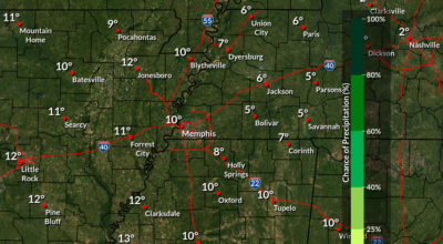
- Winter weather is not over yet. (NWS)
A new Winter Weather Advisory from the National Westher Service warns that freezing rain, a hard freeze and treacherous roads are expected from 6 a.m. to 7 p.m. Thursday. Total ice accumulations of a “light glaze” will cause “very slippery sidewalks, roads and bridges. … The hazardous conditions could impact the morning or evening commute.”
“Numerous roads across the Mid-South remain snow and slush covered from the recent winter storm,” the NWS reported. “Some melting of the snow has occurred on treated roads [Wednesday] due to abundant sunshine and temperatures in the upper 20s and lower 30s.
“Temperatures will fall back into the teens and lower 20s across the area tonight with re-freezing of precipitation on roads expected to produce treacherous road conditions. Bridges and overpasses will be especially dangerous tonight, as they quickly [refroze] after sundown.
“Additionally, black ice will be a major concern tonight as any wet and patchy covered pavement refreezes. Extreme caution should be exercised if you must travel.”
Drivers are encouraged to slow down and use caution while traveling. For the latest road conditions for the area, call 511.
Residents should prepare for possible power outages considering the Hard Freeze Warning still in effect until tomorrow. Sub-freezing temperatures from around 10 degrees far northwest to the low 20s far southeast are expected. Frost and freeze conditions will kill crops, other sensitive vegetation and possibly damage unprotected outdoor plumbing. Take precautionary steps to protect tender plants from the cold.
To prevent freezing and possible bursting of outdoor water pipes, pipes should be wrapped, drained or allowed to drip slowly. Those who have in-ground sprinkler systems should drain them and cover above-ground pipes to protect them from freezing.
An extended NWS forecast is as follows:
Tonight
Mostly clear, with a low around 17. Wind chill values as low as 6. South southeast wind 5 to 10 mph.
Thursday
A chance of freezing rain before noon, then rain or freezing rain likely between noon and 1 p.m., then rain likely after 1 p.m. Cloudy, with a high near 36. South southeast wind 5 to 10 mph. Chance of precipitation is 70 percent. Little or no ice accumulation expected.
Thursday Night
Mostly cloudy, with a low around 23. West southwest wind 5 to 10 mph becoming northwest after midnight.
Friday
Mostly sunny, with a high near 30. North northwest wind 10 to 15 mph.
Friday Night
Mostly clear, with a low around 10. North northwest wind 5 to 10 mph.
Saturday
Sunny, with a high near 24. North wind 10 to 15 mph.
Saturday Night
Mostly clear, with a low around 10. East northeast wind around 10 mph.
Sunday
Mostly sunny, with a high near 35. East wind 5 to 10 mph.
Sunday Night
Partly cloudy, with a low around 23.
Monday
A 20 percent chance of rain after noon. Partly sunny, with a high near 46.
Monday Night
A 50 percent chance of rain. Mostly cloudy, with a low around 35.
Tuesday
Rain likely. Cloudy, with a high near 54. Chance of precipitation is 60 percent.
Tuesday Night
Rain likely. Mostly cloudy, with a low around 45. Chance of precipitation is 60 percent.
Wednesday
Rain likely. Cloudy, with a high near 59. Chance of precipitation is 70 percent.